7 results with digital objects
Show results with digital objects
RW 191
·
Collection
·
1974-1981
Subject and correspondence files.
Stephen Lusher, politician
RW 357
·
Collection
·
1974-1984
Subject and correspondence files.
Stephen Lusher, politician
RW 3537
·
Collection
·
1985 - 2022
Papers relating to the opening of the Hume and Hovell Walking Track and various track maps, NSW Department of Lands Annual Report 1989-1990. Papers relating to the official opening of the Williams Hydroelectric Power Station, Mannus Lake, Tumbarumba, in 1986. Echuca-Moama Draft Crown Land Assessment by the Department of Conservation and Land Management, June 1993. Coleambally Draft Crown Land Assessment by the Department of Land and Water Conservation, June 1995. NSW Land and Water Conservation Murrumbidgee Region Staff Directory, 1996. NSW Department of Lands - Murrumbidgee River Waterside Reserves (Maps show Murray River to Maude, Uara Creek to Darlington Point, Darlington Point to Wagga Wagga, Wagga Wagga to Lake Burrinjuck.
Ray Mullins
SA 1090
·
Collection
·
1888-1985
Aerial photographs, parish, town and property maps, including map of Murrumbidgee River Flood catchment area.
NSW Crown Lands, Wagga Wagga Office
SA 316
·
Collection
·
1951-1963
Administrative files relating to individual Crown Land portions.
Cootamundra Land Office
RW 1193
·
Collection
·
1921-1985
Topographical maps
Dr David Denholm
RW 1194
·
Collection
·
1922-1989
Maps, plans, overlays, data and other papers relating to Wagga Wagga and the surrounding district.
Dr David Denholm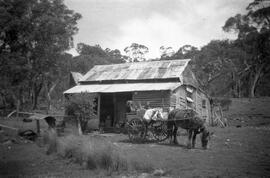
RW 1247
·
Collection
·
1923 - 1976
Photographs and negatives taken around Tumut and Kosciusko National Park, notebook and newspaper clippings.
Albert Green, labourer and photographer