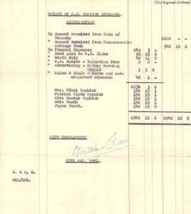
RW 3430-03
·
Item
·
c.1968
Part of Harold Carey, amateur photographer and pilot
![Dame Mary Gilmore: Teacher, Reformer and Poet [newspaper clipping]](/uploads/r/rw/a/f/9/af9c08fbfeaeca3bfcbf563f0a665a3144f6d60e0324671220d818fced5948f5/RW114-17aTRUE_142.jpg)
![De Gruchy & Co.'s New Squatting Map of Riverina District of NSW shewing all the townships, reserves, roads, stations, &c. &c. with their appproximate boundaries and replete with general information to the latest dates: togehter with alphbetically arranged index of all the Squatting Stations 1877 [lithograhed and published by De Gruchy & Co. 21 Elizabeth St, Melbourne]](/uploads/r/rw/2/3/2/2329958d34e3787632452358fbdab31cb6144f92eb72528525c1933913b33d80/RW5_070_142.jpg)
![Front side of photograph of a group of people on the ship "Karoola" in Melbourne [incl. Edwards, Townsend, McAlaster, Morrison, Stuart, and Edney]](/uploads/r/rw/b/d/8/bd89b9e6e0a9a493301a58ed6f732642dc3c991fb7eeb48b26d295ba90641292/RW5_099_142.jpg)